

By Chris Webber
Blue Mountains National Park has Australia’s largest network of walking tracks, covering over 250 kilometres. In addition, Blue Mountains City Council (BMCC) manages 135 km of walking tracks, more than 90 lookouts and five bushland campgrounds.
The National Park is the most visited destination in NSW, with over four million visits per year. According to the NSW National Parks and Wildlife Service (NPWS), walking is the most common activity undertaken, with 76 per cent of those visitors engaging in walking or bushwalking during their visit.
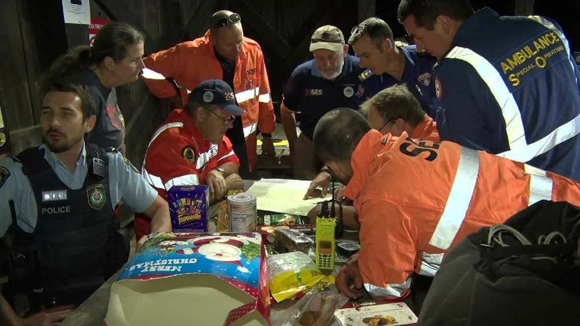
Police Rescue, Ambulance Special Operations, and Oberon SES working together on a search in the Kanangra Boyd National Park, 20 January 2018
The large number of visitors keep the local emergency services busy, with, on average, about one rescue operation every other day (concentrated on weekends and holidays, with up to nine being recorded in one day). There were 188 such incidents in the last financial year, including 53 resulting from a person getting lost. Only 14 involved a PLB activation, with the most common reason for a helicopter rescue being an ankle injury.
A rescue operation usually involves one or two people but can involve up to 14. This means that between 200 and 400 people are rescued every year, and the number increases by about 10% p.a. For the June long weekend in 1992 alone, due to bad weather, 114 people were rescued. Emergency services and volunteers play a vital role in responding to these incidents, with their professionalism and teamwork helping to keep bushwalkers safe.
The Blue Mountains Police Rescue Squad has the responsibility for managing search and rescue incidents in the Blue Mountains. If you need assistance, call 000.
How is the local environment changing, and how will the changes affect visitors and bushwalkers?
Heatwaves
An increasing number and length of heatwaves and increase in the number of days above 35°C may lead to an increase in the number of cases of Hyperthermia and Hyponatremia. How frequently they occur is unknown; they are relatively rarely reported, as usually the patient recognises the symptoms and self-evacuates.
On a day walk, they are usually on the latter stages of a walk when they run out of water - and start vomiting while climbing stairs, for instance. Heat-related illness and dehydration can pose serious risks, particularly on longer walks where access to drinking water is limited or unreliable.
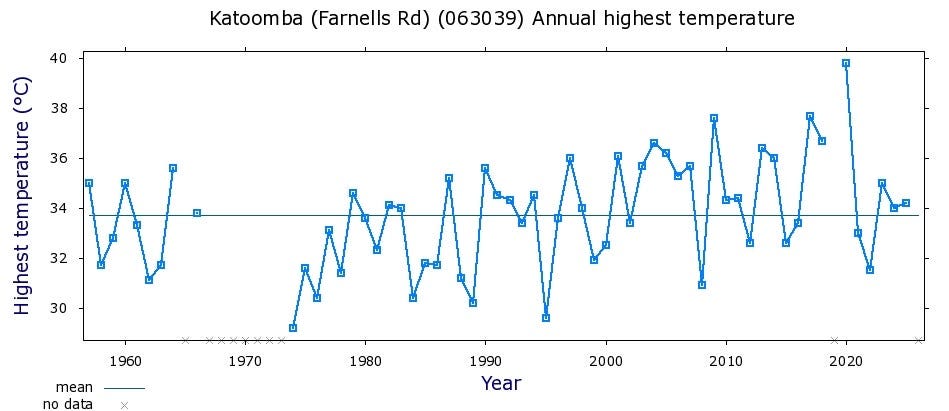
Highest annual temperatures recorded in Katoomba, 1967-present
An increase in the number of very hot days may lead to a decrease in the number of people undertaking walks overall (in summer) and an increase in popularity of walks that lead to waterfalls and swimming holes.
A warm day during a long weekend last year led to a situation where 75 vehicles were crowded into and around the Minnehaha Falls reserve car park, a space more suited to seven vehicles. Growing visitor numbers at popular swimming locations can create additional safety and access challenges, particularly during peak periods.
Increased numbers of people can be expected at the Jellybean Pool (where a seven-year-old drowned in 2020), the Blue Pool, and Paradise Pool. More unprepared Instagrammers can be expected to attempt to get to the so-called “infinity pools” at the end of Fortress Canyon and in Leura, and to attempt to navigate canyons like Dalpura Canyon.
Bushfires
It is expected that there will be an increasing number of severe fire weather days (FFDI>50) and longer bushfire seasons. Fortunately, there have been frequent rains since 2021 and fires have been rare. The rain has caused a huge amount of regrowth, and a repeat of the 1957 situation is possible if there is another drought. Also, many tracks have become overgrown and experienced walkers have had to be rescued because they were unable to cover ground in the expected time.
The track most affected is the Kanangra to Katoomba track. One man attempting that walk nearly died of thirst while sitting in the Coxs river, because he had used up all his water and had been unable to fight through the undergrowth quickly enough to get there before his kidneys started to pack up. Luckily, he had a PLB and called for help.
Bushfires can significantly change walking conditions, with fallen trees, debris and damaged vegetation making tracks difficult to navigate or temporarily inaccessible. Bushwalkers should check current track conditions, park closures and fire danger ratings before setting out, particularly following a bushfire or during periods of increased fire risk.
The NPWS has become more pro-active and closes national parks if there is an extreme fire threat, so there may be fewer days when you can enjoy a bushwalk but it will be safer. Fortunately, very few bushwalkers have died in fires – four in 1957 and one in 1982. The body of the latter was found next to the memorial to the former, at Perrys Lookdown.
Storms
The Blue Mountains experiences significant storms. In the 1980s, winds of 210 kph and 175 kph were recorded. The worst incident occurred on the night of 5-6 July, 2011. Winds rose to 139 km/h and the SES received more than 1,100 calls for assistance, mainly in the Blackheath area. Strong winds can bring down trees and branches, creating hazards for bushwalkers both during storms and in the days that follow.
Having warmer winters, springs, and autumns, along with less rain overall, makes for some pleasant walking weather but it has to be remembered that the infrequent rainfall will be more likely to be heavy and sudden, with high winds. It’s easy to protect yourself by checking the local weather forecast and registering your walk on the NPWS TREK page. The latter will then automatically alert you to events that might affect your walk.
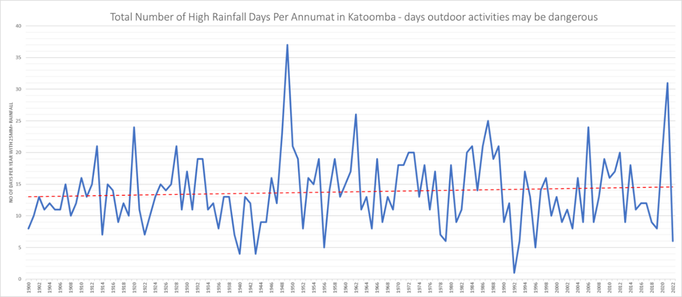
Number of days it rained 25mm or more per annum (page 145, “Mountains Mishaps, 2nd Edn”)
The annual average rainfall, particularly in spring and winter, is predicted to decrease. Earlier this year, a severe thunderstorm was observed from Hawkesbury Heights to begin to rotate just like the precursor to a tornado.
The possibility of more severe storms means more lightning strikes. Lightning can be very dangerous for rock climbers in particular, as the lightning travels across wet rocks and through metal fittings, and rock climbers are often unable to get to shelter quickly.
Incidentally, bushwalkers have been hit by lightning while sheltering inside a cave on top of a ridge – the rock they were sitting on contained ironstone, and the lightning travelled through the rock above them. That situation can probably be avoided by sheltering in a cave further down the side of a ridge rather than near its top.
An increasing number of severe rain events is expected. People often get trapped or even drown in severe weather (e.g. in the Valley of the Waters or in canyons). NPWS has been reacting pro-actively to this also, not waiting for the event but closing tracks if severe weather is forecast.
A decrease in water quality at popular swimming locations is another possible consequence of increasing severe storms. The water quality at Wentworth Falls Dam was given “Poor” rating by the 2025 NSW State of the Beaches report. The Dam now has signs warning people not to swim there after it has been raining. The increasingly popular, and often over-crowded swimming hole at the base of Minnehaha Falls received a ‘Very Poor’ rating in the same report.
The Katoomba area receives the highest rainfall of the Sydney region. The highest daily rainfall was 285mm in 1978 and falls of around 200mm have happened several times in the region. Weekly rainfalls have reached 400 or even 500mm.
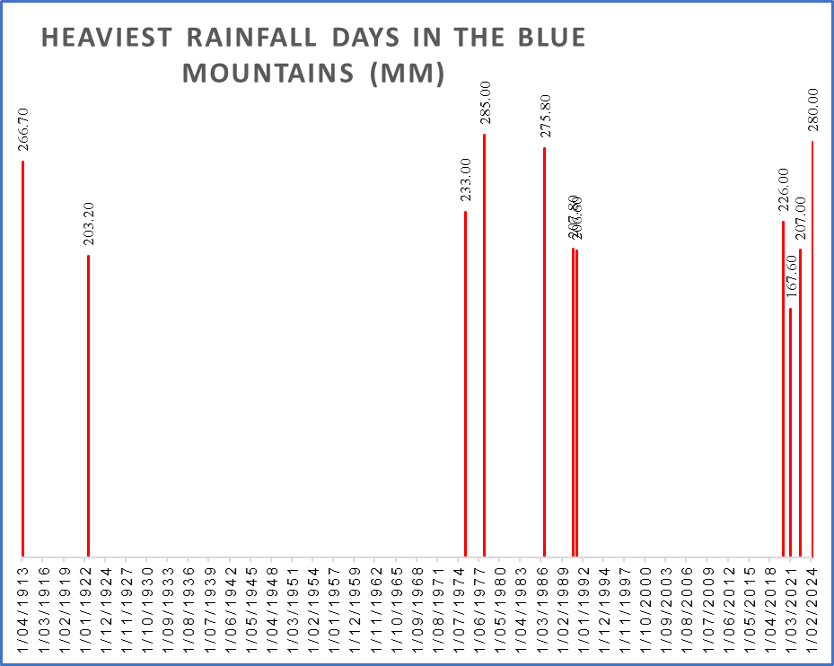
Graphing the most extreme rainfall events shows that they have nearly all happened within the last few decades, exactly as predicted by climate science.
Heavy rainfall can increase the risk of landslips, rockfalls and flooding, affecting walking tracks and access roads. Following significant rainfall, tracks may be temporarily closed while the National Parks and Wildlife Service assesses conditions and potential hazards. Significant rainfall can also affect road access, with landslips and other damage sometimes requiring complex assessment and repair work before roads can safely reopen.
The Wolgan Valley Road, the only access route to Newnes and the Wolgan Valley, a popular bushwalking, camping and canyoning area, was closed in November 2022 after heavy rain caused multiple landslides. There is still no confirmed date for its re-opening.
Jenolan Caves has had similar problems and will not re-open until 2027. The Six Foot Track has thus had to be terminated where it meets the Jenolan Caves Road, and most people only walk as far as the Coxs River from Katoomba and return.
Successive severe weather events have caused significant damage to roads and other infrastructure across the Mountains. Recovery and repair works can be complex, particularly when further rainfall affects already damaged areas.
Floods
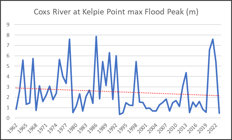
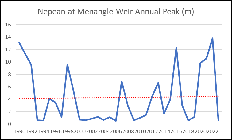
Peak flood levels in the local rivers are rising, while their average water levels are falling. This indicates that there is an increasing problem with run-off. Although many local rivers flow through relatively remote areas, rapidly rising water levels can present significant risks to bushwalkers, particularly those camping or crossing waterways.
Experienced walkers or walkers using old guide books will need to be aware that a place that was safe to camp in the past may be less safe now, as the river will rise higher than it used to and a sudden severe change in the weather is possible.
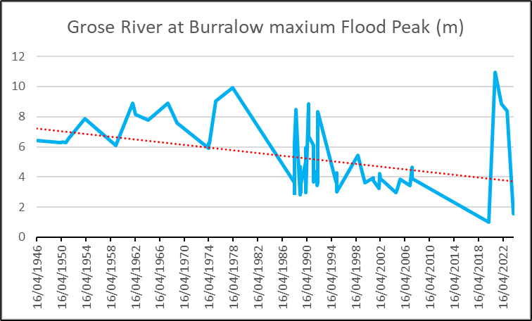
Peak flood levels (blue line) and average water levels (red line) in the Grose River (page 160, “Mountains Mishaps, 2nd Edn”). The Nepean and Coxs River trends (below) are similar.
The Grose River floods, on average, twice a year. There are some small dams above the Grose Valley, one of which has been the subject of white alerts a few times when water seemed about to over-top it. Although a dam failure is very unlikely, the increasing occurrence of sudden intense rainfall makes it a possibility. That part of the National Park is uninhabited but the NPWS estimates that there are 1,500 bushwalkers and other people in the Grose Valley at any one time who might be affected.
Snowfalls
Snowfall has become less frequent in the Blue Mountains, although significant snow events can still disrupt walking tracks, roads and essential services. There used to be snowfalls every year, but for the last three years, snow has not settled east of Oberon. The last significant event was in 17 July 2015, when an east coast low caused up to 20cm snow to fall. The snow contains more water than snow in higher elevations, so it’s heavier. Also, the trees aren’t adapted to carry it. Many trees were brought down by the weight of the snow, this blocked walking tracks and roads.
The railway line closed because train drivers couldn’t get to the Mt Victoria depot. Shops in Katoomba were closed most of the day as staff could not get to work. The hospital would have closed if staff had not been ferried to and from there in emergency service vehicles.
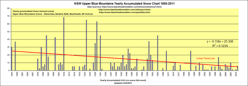
Snowfalls in the Blue Mountains (“Mountains Mishaps”, 2nd Edn, page 366)
Invasive pests and weeds
The spread of some feral animals and plants into the Blue Mountains is probably favoured by climate change. Some of these creatures aren’t just degrading the local environment, they can be annoying to bushwalkers. For instance, anecdotal evidence indicates that ticks are being seen where they haven’t been seen before, as well as chiggers.
Chiggers are the microscopic larvae of mites that like to bite people. They are found in warm, moist environments, typically near rivers. They may be carriers of scrub typhus. Leeches also prefer warmer weather and seem to be spreading to new locations.
Avoiding risk
Although the risks to bushwalkers may be increasing, the means of avoiding and surviving them are getting better and easier. BMCC provides an online Emergency Dashboard, bringing together information and updates about local emergencies, weather warnings, road conditions and other potential hazards.
You can install some free apps on your phone such as Hazards Near Me, Emergency +, BOM, National Parks, various mapping apps and a First Aid app. You can borrow a Personal Locator Beacon (PLB) free from the National Parks centre in Blackheath and PLB response times are down to 1.5 hours. Some of the latest phones now have PLB capabilities and Telstra has introduced a satellite service for mobile phones.
While experience may not now be as reliable as it was, most of these hazards can still be avoided with proper preparations and equipment. Check the weather forecast for the region (not the Sydney forecast). Register your walk on the NPWS TREK page. Bring enough food and water. Wear the right clothes and bring the right equipment. Basically, follow the TREK procedure and you will be fine.
The NPWS TREK page is at https://www.nationalparks.nsw.gov.au/safety/bushwalking-safety/think-before-you-trek.
About the author
Chris Webber has been a member of Blue Mountains SES for 25 years. He is the author of “Mountains Mishaps: death and misadventure in the Blue Mountains” available from https://mountainsmishaps.com.au
This book, sponsored by the NSW Government and SES VA, tells the story of local rescues and climate change through 650 incidents that caused 230 deaths.
The data in this article was supplied by the NSW Police (via a Freedom of Information request), the BOM, Blue Mountains City Council, Sydney Water, and from pages 27-29 of “The Upper Grose Valley: Bushwalkers Business” by Michael Keats and Brian Fox.